Tour the 3000m “Digital Botanical Garden” with Mr. Yoshinori Murai
Overview and Charm of Mt. Norikura
Mt. Norikura is a magnificent mountain located at the southern end of the Chūbu-Sangaku (Central Alps) National Park. Its vast mountain range stretches about 15 km from north to south and 20 km from east to west, spanning both Matsumoto City in Nagano Prefecture and Takayama City in Gifu Prefecture. The name “Norikura” (“Riding Saddle”) comes from its shape, which resembles a horse’s saddle.
- Main Peak: Kengamine
With an elevation of 3,026 meters, Kengamine is the highest peak of Mt. Norikura. - 23 Peaks and 7 Ponds
The entire Mt. Norikura area features 23 peaks over 2,500 meters in elevation, 7 ponds (lakes), and 8 plateaus. - Active Volcano
Mt. Norikura is an active volcano whose volcanic history began more than one million years ago, and its present form took roughly 300,000 years to shape. Submission of a climbing registration form is required. - Japan’s Highest Drivable Point
Thanks to the opening of the Norikura Skyline and Norikura Echo Line, Tatamidaira (an alpine area over 2,700 m) once became Japan’s highest point accessible by car. However, to protect the natural environment, private vehicle restrictions are now in place. Please use shuttle buses or taxis instead. - How to Enjoy Mt. Norikura
From mid-May, when the Norikura Skyline opens, until its closure at the end of October, visitors can enjoy a safe and relatively easy mountain hiking experience above 2,700 meters, starting from Tatamidaira, according to their fitness level.
The view from Kikyō-ga-hara on the Norikura Skyline.
Example: Traveling from Takayama Bus Center via Nōhi Bus (May 15 – October 31)
| *Destination | 10:30 Mt. Norikura Summit Hut (3,000 m) |
|---|---|
| ↑ Tatamidaira | 8:40 Norikura Tatamidaira (2,702 m) – Kata-no-Koya Hut (2,750 m) |
| ↑ Stopover Point | Hōnoki-daira 7:43 arrival, 7:55 departure, bound for Norikura Tatamidaira |
| Departure Point | 7:00 Takayama BC (573 m) |
After enjoying the 3,000-meter view and nature experience at the Kengamine summit, you can descend and travel to Takayama City, Okuhida Onsen-gō, Matsumoto City, and other locations by that evening.
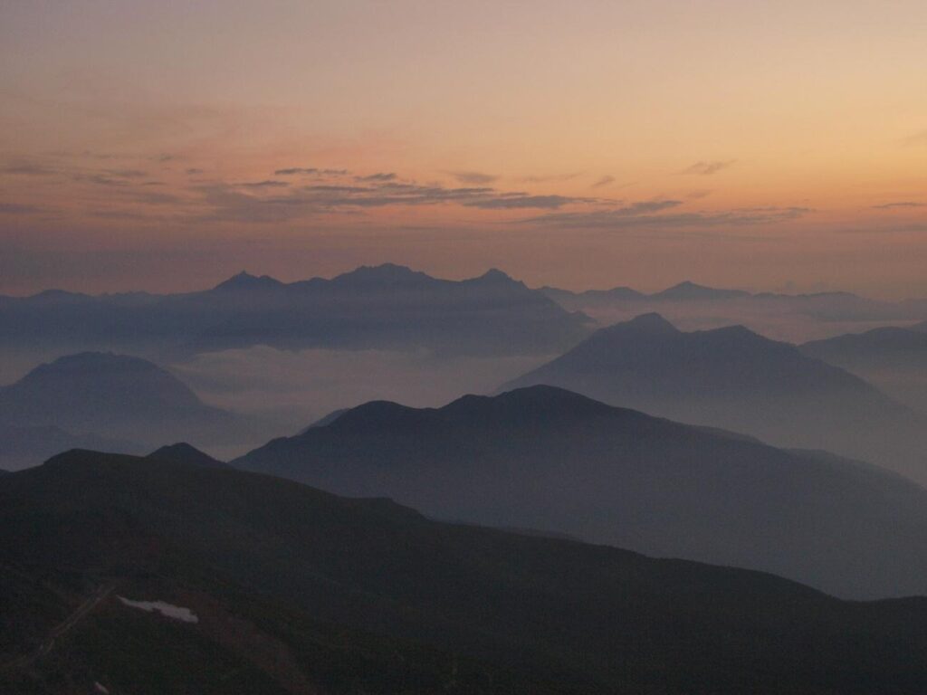
View from the Summit Hut area at sunset.
Hiking Guide
Starting from Tatamidaira, you can climb the main peak, Kengamine (the highest point), as well as three surrounding peaks near Tatamidaira: Mt. Fujimi-dake, Mt. Daikoku-dake, and Mt. Maō-dake—a total of four peaks—depending on your physical condition and circumstances.
1. Kengamine (3,026 m)
As the main peak of Mt. Norikura, you can experience an elevation of over 3,000 m with a moderate effort, provided you take safety precautions. Pay extra attention during the descent!
Course Outline
① From Tatamidaira, follow the Tsuruga-ike promenade, keeping Tsuruga-ike Pond on your left. Turn right at the prefectural border plaza, pass the Fujimi-dake trailhead on your left, and take the designated road to Kata-no-Koya Hut.
② Descend the stairs next to the Tatamidaira bus terminal, follow the flower meadow promenade towards Fukei-ike Pond, ascend the stairs just before the pond to reach the designated road, and then proceed to Kata-no-Koya. (Accessible from around June.)
③ From Tatamidaira, follow the Tsuruga-ike promenade as in route ①, ascend to the summit of Fujimi-dake from its trailhead, then descend to the designated road and continue to Kata-no-Koya.
Note: Do not enter the road on the right that leads to the former Corona Observatory. Take a short rest, check your condition, and use the restroom at Kata-no-Koya before continuing.
Attention: There are no toilets along the mountain trail or at the summit of Kengamine.
From Kata-no-Koya to the Summit
Elevation gain: approx. 250 m Distance: approx. 1,200 m. Estimated Time: 60 minutes for the ascent, 40 minutes for the descent (take your time and proceed leisurely).
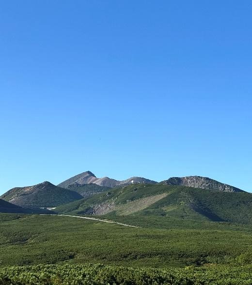
The Mt. Norikura Main Peaks. Kengamine is the left peak, Koma-dake is the central peak, and Asahi-dake is the round peak on the right.
Route
- Initially, the path is covered with andesite rocks, flanked by creeping pine. The slope becomes steeper around a slight curve, and the scree slope worsens, so be careful of loose rocks. The midpoint is marked by a large rock on the left.
- After climbing the rocky slope of Mt. Asahi-dake, you will arrive at a saddle where the deep blue Gongen-ike Pond comes into view.
- At the summit of Koma-dake (2,979 m), observe the condition of the Kengamine summit and adjust your physical condition or timing for congestion.
- To reach the summit, proceed to the left of the cairn with the directional sign at the fork to arrive at the Summit Hut.
- After enjoying the view of the Northern Alps, Yatsugatake, and the Southern Alps (centered around Mt. Fuji) from the terrace in front of the Summit Hut, proceed to the true summit.
Summit
- Panorama
In front of you are the peaks of Norikura, including Mt. Dainichi-dake—the second-highest peak of the Norikura range—and Mt. Byobu-dake, along with other surrounding peaks. If weather permits, you can enjoy a sweeping view of Mt. Ontake, Mt. Hakusan, the jagged peaks of the Northern Alps, and even distant ranges such as the Southern Alps, Central Alps, and Tateyama Mountains. - Descent Precautions
The summit area is not very large, so please descend promptly after resting. Watch out for loose and falling rocks. Never touch or step on rocks marked with an X, as they indicate danger.
Peaks Around Tatamidaira
- Mt. Maō-dake (2,764 m)
This is the easiest and quickest peak from Tatamidaira, ideal for enjoying the scenery and atmosphere of Mt. Norikura. Estimated Time: Approx. 20 minutes for the ascent. View: On the way, you will look down upon Tsuruga-ike Pond and Kamega-ike Pond on both sides before reaching the summit park. A panoramic view of the Northern Alps can be enjoyed from the park. - Mt. Daikoku-dake (2,772 m)
This is a rock ptarmigan habitat, where the chance of observation is high. Estimated Time: Approx. 30 minutes for the ascent from Tatamidaira. View: From the park, you can see the peaks of Mt. Kurobegoro, Mt. Kasagatake, Mt. Sugoroku-dake, Mt. Yarigatake, and the Hotaka Mountain Range, centered around the smoking Mt. Yake-dake. If weather permits, you can even see the peaks of Northern Shin’etsu and Southern Shin.
Note: As this is a rock ptarmigan habitat, please stroll as quietly as possible. - Mt. Fujimi-dake (2,817 m)
Unlike Mt. Maō-dake, which is a dead end, this mountain allows for a ridge walk experience towards Kengamine.Estimated Time: Approx. 45 minutes from Tatamidaira to the Rock Ptarmigan Monument.
Trail Condition: It is generally scree-covered.
View: From the summit, you can see all of Mt. Norikura, as well as the Norikura Kōgen village and Matsumoto City below. Depending on conditions, you can even see Mt. Fuji in the distance.

Near the Prefectural Border Gate on the Norikura Echo Line. Mt. Maō-dake is the peak on the left, and Mt. Daikoku-dake is the peak on the right. The pond is Tsuruga-ike.

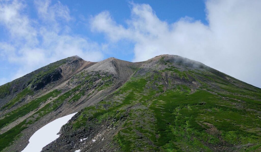
Fujimi-dake Summit. The highest peak ahead on the right is Kengamine. The dome of the former Corona Observatory on the far right has been removed.
Nature Observation Guide (Plants and Animals)
Mt. Norikura is a treasure trove of nature, rich in diversity, where animals such as alpine plants and the national Special Natural Monument, the Rock Ptarmigan, live.
Alpine Plants
Depending on the climate, approximately 60 species of alpine plants can be observed for about three months, from mid-June to late September.
- Famous Observation Spots
While the vast colonies of Hakusan Ichige (Anemone narcissiflora) in the Tatamidaira flower meadow are particularly famous, in recent years, the large colonies of Komakusa (Dicentra peregrina), known as the “Queen of Alpine Flowers,” found on the scree slopes to the left side of the trail between the middle and saddle area of the Kengamine trail, have become a highlight. These beautiful flowers can be observed along the trail and in the distance from early July through late September. - Tatamidaira “Flower Meadow”
A circular walking route of about 30 minutes, where numerous flowers can be viewed at once depending on the season. - “Tsuruga-ike Promenade”
Flowers can be enjoyed together with the characteristic scenery of Mt. Norikura. - “Kata-no-Koya Trail”
A trail next to the Daisekkei (Great Snow Valley) that reaches its peak bloom late in the season. - Various other locations, such as alongside mountain trails and roads.
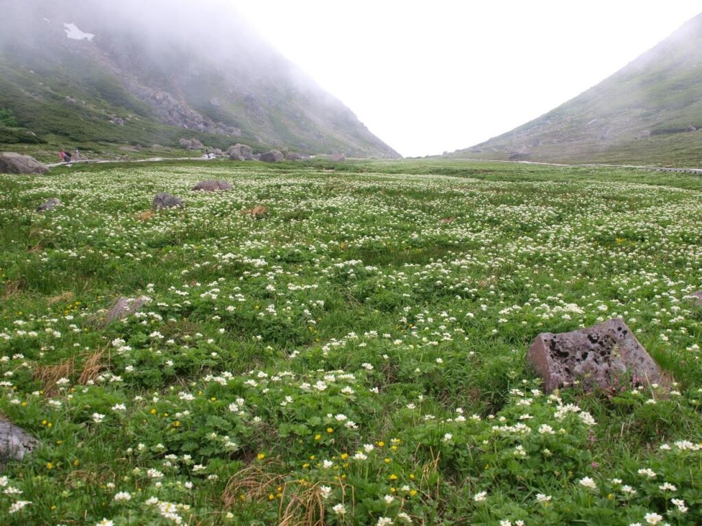
The Tatamidaira Flower Meadow when the Hakusan Ichige are in full bloom.

Komakusa colony near the midpoint of the Kengamine trail.
Main Species (Approx. 60 Types)
Yellow Rhododendron, Black Lily, Chinguruma, Alpine Stellaria, Alpine Ragwort, Komakusa, Creeping Pine, Shinano St. John’s Wort, Hakusan Ichige, etc.
Animals
The animal representing Mt. Norikura is the Rock Ptarmigan, designated as a national Special Natural Monument.
- Rock Ptarmigan : Recent surveys estimate that 40 pairs, totaling about 100 birds, inhabit the area. Observation Period : Various forms can be observed along the mountain trails, such as those retaining their white winter plumage when the Norikura Skyline opens on May 15, or family groups with several chicks in July.
- Other Bird Species : You can observe the distinctive flying figure of the eye-catching Spotted Nutcracker, as well as the Alpine Accentor, Eurasian Crag Martin, and Japanese Accentor, among others.
- Mammals : Sightings of the Asian Black Bear have increased in recent years. Please carry a bell or other noise-making item as a precaution against bears. Japanese Red Fox and Stoat (ermine), which prey on rock ptarmigan, also inhabit the area. Occasionally, you can observe the Japanese Serow standing on the snow-capped peaks.
- Insects : Several species of butterflies and bees visit the area when the flowers are in full bloom.
Safety Guidelines for an Enjoyable Visit
Mt. Norikura is a high-altitude area full of attractions such as alpine plants and panoramic views. At the same time, it is also a potentially dangerous environment where there is little shelter from wind and rain. Because of its valuable remaining nature, it is designated as a strictly regulated Special Protection Area.
Precautions Regarding Hiking and Weather
- Equipment and Planning : Please be prepared with complete equipment and a plan that allows for plenty of time.
- Sudden Weather Changes : Weather changes on Mt. Norikura are sudden and rapid, and recovery tends to be delayed. Tatamidaira (elevation 2,700 m) is an alpine area above the tree line, where weather changes are diverse and dramatic.
- Air and Perceived Temperature : It is said that the temperature drops by about $0.6text{°C}$ for every 100 m increase in altitude, and with the effects of wind and wetting from rain or fog, the perceived temperature drops even further.
- Mountain Trails : Some sections of the trail are covered with sand, gravel, and loose rocks, and there are also topographically dangerous spots.
- Behavior During Hiking :
- If you feel unwell, descend immediately.
- Even on mountains that can be completed round-trip from Tatamidaira in under an hour, the elevation is over 2,700 m. Be aware of sudden weather changes.
- Mt. Norikura is a bear habitat. Carry a bell or other noise-making item to maintain an appropriate distance, and hike in groups.
- Please refrain from hiking late in the afternoon.
- Emergency Contact : There is no specific contact point for emergency calls or aid for altitude sickness or injuries. During the busy season from July to October, you can receive a doctor’s examination at the clinic located at the bus terminal on Saturdays and Sundays.
Rules for National Park and Environmental Conservation
To pass on the valuable nature of Mt. Norikura to future generations, please strictly observe the following rules.
- Walk on designated trails and do not stray from the paths.
- Do not pick alpine plants (including trees, bamboo, stones, soil, etc.). Do not step on the plants.
- Take your trash home with you.
- Do not litter cigarette butts. Do not make open fires.
- Please keep the restrooms clean.
- Do not bring pets into the area.
Summary
Mt. Norikura is a mountain park where everyone—from beginners to experienced climbers—can find inspiration suited to their ability and develop a love for the mountains. Please enjoy its majestic scenery and diverse nature safely and responsibly by following the rules.

A male Rock Ptarmigan looking at snow-covered Kengamine immediately after the Norikura Skyline opened.